
Roughly half of Nova Scotians rely on groundwater for their domestic water supply. In the Annapolis Valley, that percentage climbs to 90% — in Kings County alone it is as high as 99%.
I’m starting with that fact not because I intend to focus on Kings County but because it gives me an excuse to share this groundwater video, produced by King County, Washington State, which I ran across while looking for more information about Kings County, NS. The video explains groundwater to “kids and adults who like watching funny cartoons while learning,” and you may consider it my Christmas gift to you all:
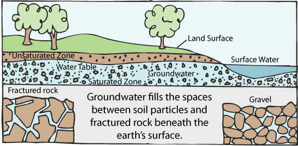
But I’m getting ahead of myself, cuing the dancing groundhogs before I even define groundwater which, according to the Province of Nova Scotia, is “water that is found below the ground surface.”
Although groundwater can be so deep underground it is impossible to access, it generally circulates as part of the “hydrologic cycle,” the:
…series of transformations that occur in the circulation of water from the atmosphere onto the surface and into the subsurface regions of the earth, and then back from the surface to the atmosphere. Precipitation becomes surface water, soil moisture, and groundwater. Groundwater circulates back to the surface, and from the surface all water returns to the atmosphere through evaporation and transpiration. (Government of Canada)
Groundwater can remain under the ground for a few days or 10,000 or more years before emerging and while underground:
…is not confined to only a few channels or depressions in the same way that surface water is concentrated in streams and lakes. Rather, it exists almost everywhere underground. It is found underground in the spaces between particles of rock and soil, or in crevices and cracks in rock.
As you can see from the diagram below, below the land surface is the “unsaturated zone,” where the spaces in the rock and soil contain both air and water. The water table is the level below which everything is saturated and the water in this saturated zone is called groundwater.
Source: Groundwater Foundation)
Some parts of this saturated zone contain more water than others, as the Government of Canada website explains:
An aquifer is an underground formation of permeable rock or loose material which can produce useful quantities of water when tapped by a well. Aquifers come in all sizes and their origin and composition is varied. They may be small, only a few hectares in area, or very large, underlying thousands of square kilometres of the earth’s surface. They may be only a few metres thick, or they may measure hundreds of metres from top to bottom.
Many important Canadian aquifers are composed of thick deposits of sands and gravel previously laid down by glacial rivers. These types of aquifers provide most of the water supply for the Kitchener-Waterloo region in Ontario and the Fredericton area in New Brunswick…
I’ll have more to say about Canadian aquifers later (part of me can’t quite believe I just wrote that) but right now I need to explain that here in Nova Scotia, according to a 2017 analysis for the provincial government, by G. W. Kennedy and A. Polegato, 91% of those accessing groundwater for domestic water pump it from drilled wells in fractured bedrock aquifers, 4% from drilled wells in surficial (shallow) aquifers (deposits of sands and gravel like the ones that supply Fredericton) and 5% from dug wells — although the authors note that dug wells are “under-reported” among the 112,883 wells in the province’s Well Logs Database.

Source: “Where Does Our Tap Water Come From? An Analysis of Domestic Water Source and Supply Demographics in Nova Scotia,” Kennedy and Polegato, 2017
About 56% of Nova Scotians obtain their domestic water from municipal water supplies, and according to Kennedy and Polegato:
Of the province’s municipal water users, most Nova Scotians (84%) are supplied by surface-water sources since the largest population centre in the province, HRM, is supplied with water from Pockwock Lake and Lake Major.
Barret Kurylyk, an assistant professor and Canada Research Chair in Coastal Water Resources at Dalhousie with whom I spoke by phone last week, told me that most municipal water systems in Nova Scotia rely on lakes because we have an abundance of them (thousands on Cape Breton Island alone). But if you’re a rural homeowner, said Kurylyk:
…unless you want to set up a large water treatment facility in your home to deal with the water quality concerns in lakes, you’re just probably pumping up groundwater, groundwater tends to be a higher quality, if you know what you’re doing..
The largest population center serviced by municipal groundwater in Nova Scotia is a little place you may have heard of called…Sydney.
Middle Lake Road
Sydney (as well as Coxheath, Westmount, Sydney River, Grand Lake Road, and Mira Road) is served by a series of deep wells, commissioned on 22 April 1996, along Middle Lake Road.
Dillon Consulting, which won the contract to evaluate potential water sources and recommended the well field also drafted a groundwater protection plan, which it presented to the CBRM in October 1996:
In the draft report of 1996 Dillon summarized the protection zones related to the wellfield and identified the potential sources of contamination located in each zone. Activities and sites of concern within the groundwater recharge area included farming, transportation, petroleum storage, former dump site and septage storage. The Dillon report also presented recommendations for protection of the water supply, including groundwater monitoring, maintaining an up to date contaminant inventory, public education, land acquisition, selecting a Wellfield Protection Committee, and developing an Emergency Response Plan.
The CBRM — which was brand, spanking new in 1996, amalgamation having taken place just a year before — responded in a way that would foreshadow its response to so many consultants’ reports in the years to come:
The draft strategy report was never finalized, nor implemented, and has been outdated with time.

Source: CBRM
In 2006, Dillon was asked to update its outdated, never-implemented groundwater protection strategy for the Middle Lake Road well field, which it did, and in 2007, the CBRM hired environmental planner Britt Roscoe as Watershed Coordinator and formed a Groundwater Protection Planning Committee which met, beginning in 2009, to “discuss sources of contamination and assess risks.”
The Middle Lake Road well field groundwater protection planning committee, which last met in 2014, recommended that council negotiate a provincial Wilderness Protection designation for the CBRM-owned land in the well field. (A full 91% of the land surrounding the well field is owned by the CBRM).
The recommendation was presented in 2011 to the CBRM Committee of the Whole which directed staff to negotiate with the province. Then, according to the minutes for that last 2014 meeting:
2014_Overview_8In April 2011, David Williams, with Nova Scotia Environment, requested a letter from CBRM that the province proceeds with the designation of certain CBRM owned lands in the Middle Lake Road well field.
[CBRM Watershed Coordinator] Britt [Roscoe] conceded that he had been unable to get a letter from CBRM, but assumes, with recent and proposed changes in CBRM administration, the letter will now be easier to obtain.
The CBRM never does seem to have gotten around to sending that letter to the province, because under “Groundwater Protection Plan” on the municipal website it says:
The watershed coordinator continues to update the groundwater protection strategy and anticipates that an updated groundwater protection strategy document might be uploaded to the website by the end of 2014.
Roscoe’s LinkedIn page shows he left the CBRM in 2014 (he’s now working independently, based in Middleton, NS). Anthony Mazzocca is now the CBRM’s Watershed Coordinator.
I started off very happily down this road when I discovered the information about water supply on the CBRM’s web site and particularly the information about municipal groundwater, but it quickly turned into a dead end. (I asked the CBRM what the status of the Wilderness Protection designation for the Middle Lake well field, but as of press time, I’d received no response.)
Observations
My conversation with Prof. Kurylyk (a native of PEI, which, in passing, depends on sandstone aquifers for its entire water supply) focused on how groundwater is monitored here in Nova Scotia.
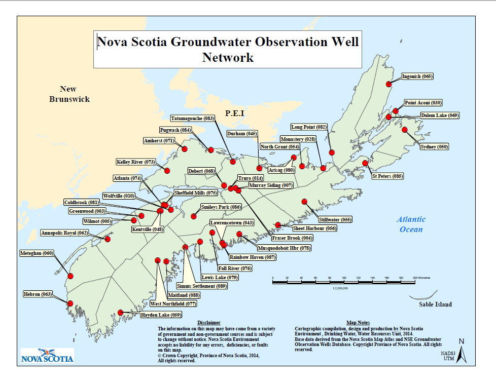
Kurylyk told me it is done largely through a network — begun in 1965 — of 40 observation wells across the province, each of which is equipped with electronic dataloggers and telemetric units that record water levels every hour (by measuring total water and air pressure and subtracting the air pressure). According to the Provincial Environment website:
The wells are visited approximately every six months for field verification and water samples are collected periodically to test groundwater chemistry.
Source: Province of Nova Scotia
In addition, says Kurylyk, the province is developing a real-time groundwater monitoring network consisting chiefly of shallow wells:
John Drage [senior geologist/hydrogeologist] at the Province came up with this kind of clever little sensor that…basically is an ultra-sonic signal that sits at the top of the well and sends down a signal or a ping and bounces back from the water surface, so it measures the distance down to the water table instead of the pressure above…[H]e can build these for $200 or something and…so he put them in a few different wells around the province, homeowners that are just interested in monitoring their water levels.
Real-time dug-well monitoring network, Nova Scotia.
Once a day, says Kurylyk, well owners:
…turn on these little sensors and measure the depth of the water table and then they’re connected to wifi, so they’re only in homes where the wifi signal is strong enough so that it’s accessible at the well — and then it pings to a website…
The once-a-day data is not as comprehensive as the data from the observation wells, but because the observation wells are mostly drilled deep, their data has to be accessed onsite which, says Kurylyk, “could be a problem in a drought.” (And, presumably, in the case of contamination.)
Drage was actually inspired to build his sensor (which is much cheaper than commercially available options) by the drought that hit the southwest part of the province, drying up wells, in 2016 and he first used it in another drought year, 2018. As Kurylyk explained, the wells that went dry were shallow wells, tapping surficial aquifers (also known as unconfined or free aquifers):
In Nova Scotia we have glaciated landscape and so the top layer is, for the most part, glacial till of some kind and in that environment, the water table can move up and down as the pressures change. But… in deeper aquifers, they may have like a confining [layer], like a low-permeability bedrock or clay or something above that’s…pressurizing the water deeper down and it’s not allowing the water level to go up or down and we call that [a] confined aquifer.
When you sink a well into a confined aquifer — also called an artesian aquifer — the water will rise because the pressure within the aquifer is stronger than the atmospheric pressure. Such wells are called — you guessed it — artesian wells. And if the water reaches the ground surface, the well is called a “flowing artesian well.”
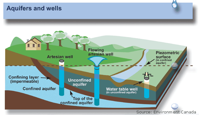
I found this illustration on the US Geographical Survey website, which I was about to credit, until I realized they’d pinched it from Environment Canada.
So the answer, when your shallow well runs dry, can be to dig a deeper well. But as the CBC reported in 2016, a dug well can cost between $3,000 and $4,000 while a drilled well can cost $10,000 or more.
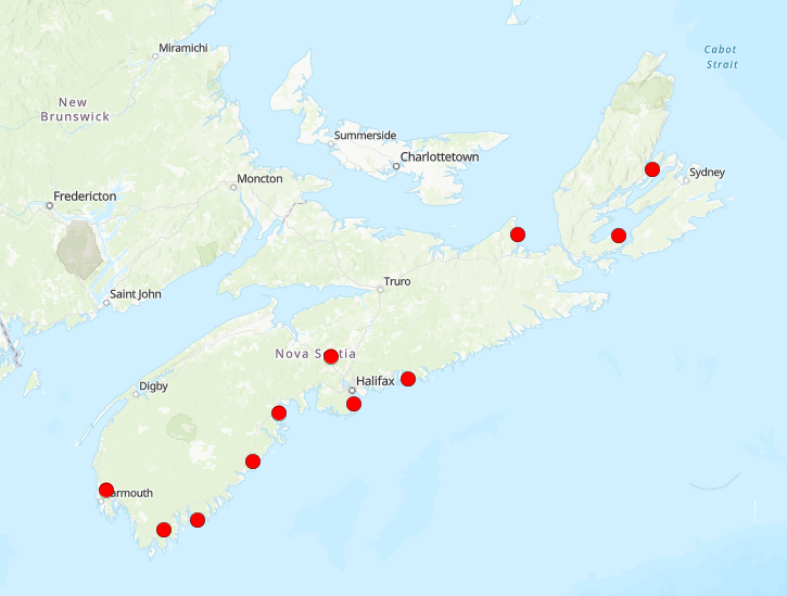
Having your shallow well go dry in a drought is one of two main climate-change related threats to groundwater supplies in Nova Scotia, the other — which is actually suggested by the location of the observation wells, clustered along the coast as they are — is sea water incursion. Said Kurylyk:
[If] you live along the coast, as you [dig] deeper, you get closer to salt water, because there’s always a saltwater wedge that comes in along the coast and it is sea water, but it’s sea water in the ground and if you drill too deeply you hit that.
The water supply challenges in Nova Scotia…in recent years have been either rural homeowners that tap the shallow aquifers with dug wells or, in the case of deeper wells, it’s been coastal communities that have hit salt water or they’re starting to see salinity levels slowly increasing in their wells. There’s some examples of communities that have moved their well field because of that in Nova Scotia, like a couple of limited examples, but there’s a lot of communities that monitor the electrical conductivity of water because that’s an indicator of the salinity.
Now that I’ve introduced the subject of climate change, I’m going to use it as a hook for the final section of this article, which I’m basing on a really interesting webinar by Fred Baechler, chief hydrogeologist and senior hydrologist for Exp. Services Inc, an adjunct professor at Cape Breton University and a research fellow at the Verschuren Centre.
Known unknowns
First, I have to confess that I didn’t have time to arrange to speak to Baechler in person (or by phone), an oversight I hope to correct in the New Year, but I watched this roughly 90-minute presentation, posted by Dr. Mark King of Groundwater Insight, and so don’t feel like a total fraud recapping some of what Baechler had to say.
Also, as soon as I said I was particularly interested in groundwater in Cape Breton, Prof. Kurylyk mentioned Baechler who, along with his wife Lynn, is apparently responsible for a lot of what we know about groundwater on the Island. Ironically, though, this presentation focuses largely on things we know we don’t know.
The title of the webinar was “Evidence for Climate Change in Cape Breton,” and although the intended audience was pretty clearly people with more knowledge of hydrology and hyrdogeology than yours truly, I still got a lot out of it. Baechler sidesteps the debate over whether climate change is man-made or a naturally recurring phenomenon, saying what matters is not what is causing it but that it is happening and we need to cope with it.
And if I had to summarize his view as to what we need to do I’d say: more research.

Baechler says understanding how climate is changing in Cape Breton is difficult because our island lies in “an extremely complicated hydrologic setting.” The Atlantic Ocean is messing with us constantly — we’ve got the cold Labrador Current meeting the warm Gulf Stream on our east coast and the warm, brackish waters of the Gulf of St. Lawrence Estuary to the west.
We’re on the receiving end of all the winds blowing across the North American continent plus we have to deal with the effects of something I didn’t even know existed, the “North Atlantic oscillation,” which controls the location of storm tracks across the North Atlantic AND we catch the tail end of hurricanes arriving from the Caribbean.
Add to that our terrain — which is apparently a Whitman’s Sampler of geological formations, including but not limited to crystalline bedrock, taiga forest, canyons, steep transition slopes, hydrologically active fault lines, hardwood Acadian forest, lowlands, sedimentary rock and hydrologically active karst regions.
Do you know what we don’t have though? We don’t have sufficient “monitoring and research.” Which is why much of the data presented by Baechler is data he has collected and collated himself, hunting it down in university theses and consultants’ reports and municipal offices and federal government databases and private companies and in the field on evenings and weekends. He notes several times during the presentation that research into a given subject has been curtailed due to funding cuts. (We used to have precipitation chemistry stations on the island but we don’t any more and so can’t monitor acid rain. We used to have 10 stream-monitoring stations on the island and we now have six, on watersheds covering about 9% of the island.)
Baechler’s got interesting data on temperatures (we have one long-term climate station in Sydney with records going back to 1895) and precipitation and Nor’Easters and thunderstorms but in every case, the data gives rise to questions rather than answering them. Take one example: snowfall.
Baechler explains how the disappearance of pack ice in the Gulf of St. Lawrence (which peaked in the mid-90s and has been declining ever since) has caused an increase in snow in the Cape Breton Highlands. That’s because the winds crossing open water in the Gulf pick up moisture which turns to snow over the Highlands. When the ice forms — which it used to do, reliably, in February — there was no moisture to pick up and so no additional snow.
But in a year like 2010, when the ice didn’t form at all, the winds continue to pick up moisture and transform it into snow for months — a snow pack began forming in the Highlands in November, peaked in March and didn’t disappear until June. I’ve copied one of the images from his presentation below. The blue graph shows snowfall in Sydney (according to data from our climate station), the red line shows snowfall in the Highlands (thanks to data from a climate station in the Cape Breton Highlands National Park — the data plateaus at the top because the snow took out the station.) The photo shows you the snow pack:

Source: Fred Baechler
If you’re thinking that I’ve wandered awfully far afield from groundwater, just wait: the melting of that ice pack has significant effects on groundwater and not just in terms of run-off and recharge but also in terms of the chemical makeup of the snow pack, which we don’t know.
I can’t even begin to cover the ground Baechler does (nor do I have to, because you can watch his presentation yourself) but I want to mention one other topic he broaches: that of sea level rise. He works with the Intergovernmental Panel on Climate Change’s (IPCC) predictions for sea rise (caused by rising temperatures), the most recent of which calls for a rise of up to 2 meters by 2100. But he also considers the possibility, raised by some researchers, that abrupt change — like the sudden melting of the Greenland and Antarctica ice shelves — could trigger a 5-7 meter rise, which he says would bring sea levels back to where they were 125,000 years ago in Western Cape Breton. Add a storm surge on top of that, and the sea level rise could be 10 meters:

Source: Fred Baechler
He brings this back to groundwater, pointing out that a 10-meter rise in sea levels would affect 72 communities on the island, including those sourcing groundwater near the ocean (or, like Eskasoni, near an inland sea).
His point, again, is that there are a lot of known unknowns in this scenario but no government research systems to try and address them. Which leads me to his conclusion (which will also serve as my conclusion as well as setting up Part II nicely).
Does it make more sense to assume a worst-case scenario for climate change or to “put more money into science and monitoring?”


